8 Best Road Trips in the USA — A Driver's Honest Guide for 2026
I have driven more than 12,000 miles across America in the past three years, and these eight routes are the ones I keep recommending — with real costs, actual distances, and the downsides nobody puts in the brochure.
There is a specific feeling you get about 200 miles into an American road trip — the playlist has settled in, the highway has opened up, and the landscape has changed enough from where you started that you feel like you are in a different country. I have chased that feeling across eight of the best driving routes in the United States over the past three years, and the list below is what I keep coming back to when friends ask me where to go. This is not a vague list of scenic drives. Every route below has a specific distance, a realistic day count, a cost range I have either spent myself or verified against 2026 prices, the three best stops, the best month to go, and — critically — the honest downside that most road trip guides leave out. I have also included a section on rental car strategy, gas budgeting, and the camping-versus-motels question, because those three decisions shape the quality of your trip more than which route you pick.
Pacific Coast Highway: San Francisco to Los Angeles (650 miles, 5–7 days)
The Pacific Coast Highway — specifically the stretch of Highway 1 from San Francisco south to Los Angeles — is the most famous road trip in America for a reason. The combination of ocean cliffs, redwood forests, and fog-wrapped bridges is genuinely dramatic, and the driving itself is engaging without being exhausting. I have driven this route twice, once northbound and once southbound, and southbound is the correct direction: you drive on the ocean side of the road, the pullouts face the water, and the light is better in the afternoon. Budget: $2,000–3,500 for two people over 5–7 days. Car rental runs $45–70/day from SFO. Gas is roughly $180–220 for the full route at California's $4.80–5.50/gallon average in 2026. Lodging is the big variable — motels along the coast run $120–200/night, while camping at state parks like Pfeiffer Big Sur ($35–50/site) cuts the bill significantly. Best month: September or October. Summer fog blankets the Big Sur coast through July, and June can be socked in for days. September clears the fog, drops the crowds, and keeps the temperatures perfect for hiking. Top 3 stops: Bixby Creek Bridge in Big Sur (the most photographed bridge in California — arrive before 9am for empty shots), Hearst Castle in San Simeon ($25 entry, genuinely worth it for the absurd grandeur), and the Santa Barbara waterfront for a lunch stop that feels like a European riviera town. Honest downside: Highway 1 closes regularly due to landslides. In 2024 alone, three sections were shut for weeks. Check Caltrans road conditions before you go, and have an inland detour plan via Highway 101. Also, the stretch between Cambria and Santa Barbara is flat, agricultural, and frankly boring — budget 2 hours of uninspiring driving through Lompoc and the strawberry fields.

Editor's tips
- Fill up your tank before entering Big Sur — there is one gas station in the area and it charges $7–8/gallon
- Book Big Sur campgrounds at ReserveCalifornia.com exactly 6 months ahead — they sell out within hours of opening
- The 17-Mile Drive through Pebble Beach costs $12.25 per car and is worth it for the Lone Cypress and coastal views
Blue Ridge Parkway: Virginia to North Carolina (469 miles, 4–5 days)
The Blue Ridge Parkway is the opposite of a highway road trip. The speed limit is 45 mph, there are no gas stations or fast food chains on the road itself, and the entire point is to drive slowly through the Appalachian Mountains with the windows down. It is the most relaxing drive in America, and the fall foliage from late September through October is among the best on the continent. Budget: $1,200–2,200 for two people over 4–5 days. The parkway itself is free — no entrance fee. Car rental from Roanoke or Asheville runs $40–55/day. Gas is roughly $100–130 for the full route. Lodging ranges from $25–40/night at parkway campgrounds to $100–160/night at mountain lodges. Best month: October, without question. The foliage peaks between October 5 and October 25 depending on elevation, and the entire road becomes a tunnel of red, orange, and gold. Spring (April–May) is the runner-up for wildflowers and fewer crowds. Top 3 stops: Milepost 431 at the Blue Ridge Music Center (live Appalachian music on weekend evenings, free), Linville Falls at milepost 316 (a 1.6-mile hike to a triple waterfall), and the Asheville area for a day off the parkway — the city has the most breweries per capita in the US and a food scene that punches well above its weight. Honest downside: The parkway is painfully slow if you are in a hurry. At 45 mph with frequent stops, 469 miles takes 4–5 full days of driving. Sections close without warning due to weather, rockslides, or fallen trees — especially at higher elevations. Check the NPS closure map daily. Cell service is spotty to nonexistent for long stretches, so download offline maps before you go.
Editor's tips
- Download the Blue Ridge Parkway app — it has milepost-by-milepost descriptions, closure alerts, and hiking trail info that works offline
- Gas up before you get on the parkway — exits to towns with stations are spaced 30–50 miles apart
- The Peaks of Otter Lodge at milepost 86 is the only lodge directly on the parkway — book 3 months ahead for October
Utah Mighty Five National Parks Loop (1,500 miles, 7–10 days)
Utah has five national parks — Arches, Canyonlands, Capitol Reef, Bryce Canyon, and Zion — and they can be driven as a single loop from Salt Lake City or Las Vegas. This is the most geologically dramatic road trip in the country. Every park looks like a different planet, and the drive between them crosses high desert, red rock canyons, and mountain passes that are worth stopping for on their own. Budget: $2,500–4,500 for two people over 7–10 days. The America the Beautiful pass ($80) covers all five park entries and pays for itself immediately versus $35/park individual fees. Car rental from Las Vegas runs $40–60/day. Gas is roughly $250–320 for 1,500 miles. Camping inside the parks costs $25–35/night; gateway-town motels run $100–180/night in peak season. Best month: May or September. Summer temperatures in Canyonlands and Arches exceed 105 degrees F, making midday hiking dangerous. October is excellent for Zion and Bryce but the high-elevation roads near Capitol Reef can get early snow. Top 3 stops: Delicate Arch in Arches (the 3-mile roundtrip hike is non-negotiable — go at sunrise to avoid the heat and crowds), the Navajo Loop at Bryce Canyon (descend into the hoodoos on a 1.3-mile trail that feels like walking through a cathedral), and Angels Landing in Zion (a 5.4-mile chain-assisted scramble that now requires a lottery permit — apply at recreation.gov 3 months ahead). Honest downside: The distances between parks are long and the roads are often empty two-lane highways with no services. Capitol Reef to Bryce Canyon is 120 miles through near-empty desert with one gas station. Reservations for campsites and permits have become extremely competitive — Zion's Angels Landing permit lottery has a roughly 15% acceptance rate. This trip requires more advance planning than any other on this list.
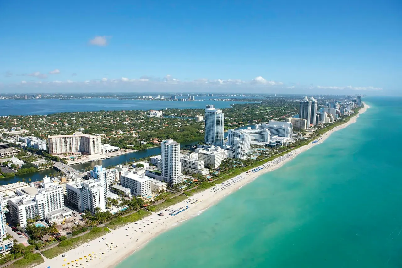
Florida Keys: Miami to Key West (160 miles, 3–4 days)
The Overseas Highway from Miami to Key West is the shortest road trip on this list and one of the most distinctive. You are driving across 42 bridges over open ocean, with the Atlantic on your left and the Gulf of Mexico on your right. The whole drive can be done in 4 hours without stopping, but that defeats the purpose — the Keys are about slowing down, fishing, snorkelling, and eating seafood at dockside restaurants where the boat came in that morning. Budget: $1,500–2,800 for two people over 3–4 days. Car rental from Miami airport runs $40–55/day. Gas is roughly $40–55 for the 160-mile route. Lodging is the expensive part — Keys hotels and motels run $150–280/night in shoulder season and $250–400+ during peak winter months. Budget travelers can cut costs by staying in Key Largo or Marathon rather than Key West. Best month: November or April. Winter (December–March) is peak season with peak prices. Summer brings humidity, mosquitoes, and hurricane risk. The shoulder months offer warm water, manageable prices, and the best fishing. Top 3 stops: John Pennekamp Coral Reef State Park in Key Largo ($8 entry — the snorkelling and glass-bottom boat tours at this underwater park are genuinely excellent), Bahia Honda State Park at mile marker 37 (the best beach in the Keys, possibly the best in Florida), and the sunset celebration at Mallory Square in Key West (free nightly street performance scene that has been running since the 1960s). Honest downside: US-1 through the Keys is a two-lane road for most of its length, and traffic on Friday afternoons and Sunday evenings can turn a 4-hour drive into 6 or 7 hours. Key West itself has become aggressively touristy and expensive — a basic dinner for two runs $80–120. The mosquitoes from May through October are genuinely awful, especially at dusk around the mangroves.
Editor's tips
- Fill up in Florida City before entering the Keys — gas prices jump $0.40–0.60/gallon once you pass Key Largo
- The Seven Mile Bridge is the most photogenic stretch — pull off at the old bridge (now a pedestrian path) for the best photos
- Key West parking is brutal — book a hotel with parking included or rent a scooter ($40–60/day) instead of driving around the island
New England Fall Foliage: Boston to Vermont to Maine (800 miles, 5–7 days)
This is a seasonal road trip — it only works in a specific three-week window — but when the timing is right, it is the most visually stunning drive in the eastern United States. The route loops from Boston north through New Hampshire's White Mountains, across Vermont's Green Mountains, and back east through Maine's Acadia National Park. Every covered bridge, white-steeple church, and cider mill you have ever seen on a New England postcard is somewhere along this route. Budget: $2,200–3,800 for two people over 5–7 days. Car rental from Boston Logan runs $50–70/day. Gas is roughly $160–200 for 800 miles. Lodging ranges widely — Vermont B&Bs run $140–220/night in October, while campgrounds at Acadia and the White Mountains are $25–40/night. Foliage season commands premium pricing everywhere. Best month: October 1–21. This is not approximate — the foliage window is real and moves south through the month. Northern Vermont and New Hampshire peak around October 1–10; southern Vermont and Maine peak October 10–21. Use the New England fall foliage tracker maps published weekly by each state's tourism board to plan your timing. Top 3 stops: Stowe, Vermont (the quintessential New England village — walk the Stowe Recreation Path for 5.3 miles of foliage along the river), Kancamagus Highway in New Hampshire (a 34.5-mile scenic highway through the White Mountains that is the single best foliage drive in America), and Acadia National Park in Maine ($35/vehicle — drive Cadillac Mountain at sunrise for the first light to hit the US). Honest downside: If you miss the foliage window, this trip loses 60% of its appeal. The peak is genuinely narrow — a week of warm weather can delay it, a single hard frost can end it early. October in New England also means foliage-chasing crowds: the Kancamagus Highway becomes a slow-moving parking lot on peak weekends, Vermont B&Bs book out months ahead, and restaurant waits in small towns hit 45–90 minutes. Go midweek if at all possible.
Going-to-the-Sun Road, Montana (50 miles, 1 full day)
Going-to-the-Sun Road in Glacier National Park is only 50 miles long, but it is arguably the most dramatic single day of driving in North America. The road crosses the Continental Divide at Logan Pass (6,646 feet), cuts through mountain walls with no guardrails, passes waterfalls that spray directly onto your windshield, and offers views of glaciers, alpine meadows, and turquoise lakes that feel closer to the Swiss Alps than Montana. Budget: $200–400 for a single day, including the $35 park entry fee (or free with the America the Beautiful pass), gas, and a packed lunch. If you stay overnight in the park or in gateway towns (West Glacier, East Glacier), add $100–200/night for lodging. Vehicle reservations are required from late May through mid-September and cost $2 through recreation.gov — book the moment they open in March. Best month: July or early August. The road does not fully open until late June or early July (snow clearing takes months), and sections can close again by mid-October. The window is narrow. Top 3 stops: Logan Pass for the Hidden Lake Overlook trail (2.7 miles roundtrip, mountain goats are almost guaranteed), the Weeping Wall where waterfalls cascade directly over the road, and Wild Goose Island viewpoint at St. Mary Lake — the most photographed spot in Montana. Honest downside: The road is narrow, winding, has no guardrails in many sections, and vehicles over 21 feet long or 8 feet wide are prohibited. If you are uncomfortable with exposed mountain driving, this road will test your nerves. The required vehicle reservation system also means you cannot be spontaneous — walk-up entry without a reservation is only available before 6am. The park's namesake glaciers are receding rapidly and most are expected to disappear by 2030, which adds an urgency but also a melancholy to the visit.
Oregon Coast: Portland to Brookings (363 miles, 4–5 days)
The Oregon Coast is what the Pacific Coast Highway would be if it had fewer people, cheaper lodging, and entire beaches to yourself. Highway 101 runs the full length of the Oregon coastline, and unlike California, every inch of Oregon's beaches is public by law — no private stretches, no gated resort access, no $25 parking lots. The landscape alternates between sea stacks, tide pools, temperate rainforest, and sand dunes, and the small towns along the way have a laid-back, slightly eccentric character that makes stopping worthwhile. Budget: $1,400–2,500 for two people over 4–5 days. Car rental from Portland runs $40–55/day. Gas is roughly $120–160 for 363 miles. Lodging is dramatically cheaper than California's coast — beachfront motels run $80–140/night, and state park campgrounds ($20–35/site) are excellent and easier to book than California's. Best month: July or August. Oregon's coast is cool and foggy for most of the year — summer is the reliable window for sun and warmth, though temperatures rarely exceed 70 degrees F even in peak summer. September is the secret best month if you do not mind risking some rain, as the crowds thin dramatically and the weather often holds through mid-month. Top 3 stops: Cannon Beach for Haystack Rock (a 235-foot sea stack rising from the beach — explore the tide pools at low tide), the Samuel H. Boardman Scenic Corridor in the south (a 12-mile stretch of cliffs, natural bridges, and coves that rivals anything on the PCH), and the Oregon Dunes National Recreation Area near Florence (40 miles of coastal sand dunes — rent a sandboard for $25 or just walk the trails). Honest downside: The weather. Even in summer, the Oregon coast can turn foggy, rainy, and cold with little warning. Pack layers and rain gear regardless of the month. The water temperature never exceeds 55 degrees F, so ocean swimming is for wetsuit-equipped surfers only. Also, the stretch between Lincoln City and Newport has more tourist-trap shops and saltwater taffy stores per mile than authentic coastal character — drive through rather than linger.
Editor's tips
- Oregon has no sales tax — stock up on gear, clothing, and souvenirs along the coast and save 7–10% versus neighboring states
- The Yaquina Head Outstanding Natural Area near Newport ($7/car) has the best tide pools on the entire coast — time your visit to low tide using the NOAA tide chart
- Cape Perpetua's Thor's Well is dramatic at high tide but dangerous — stay behind the marked barriers and check wave conditions
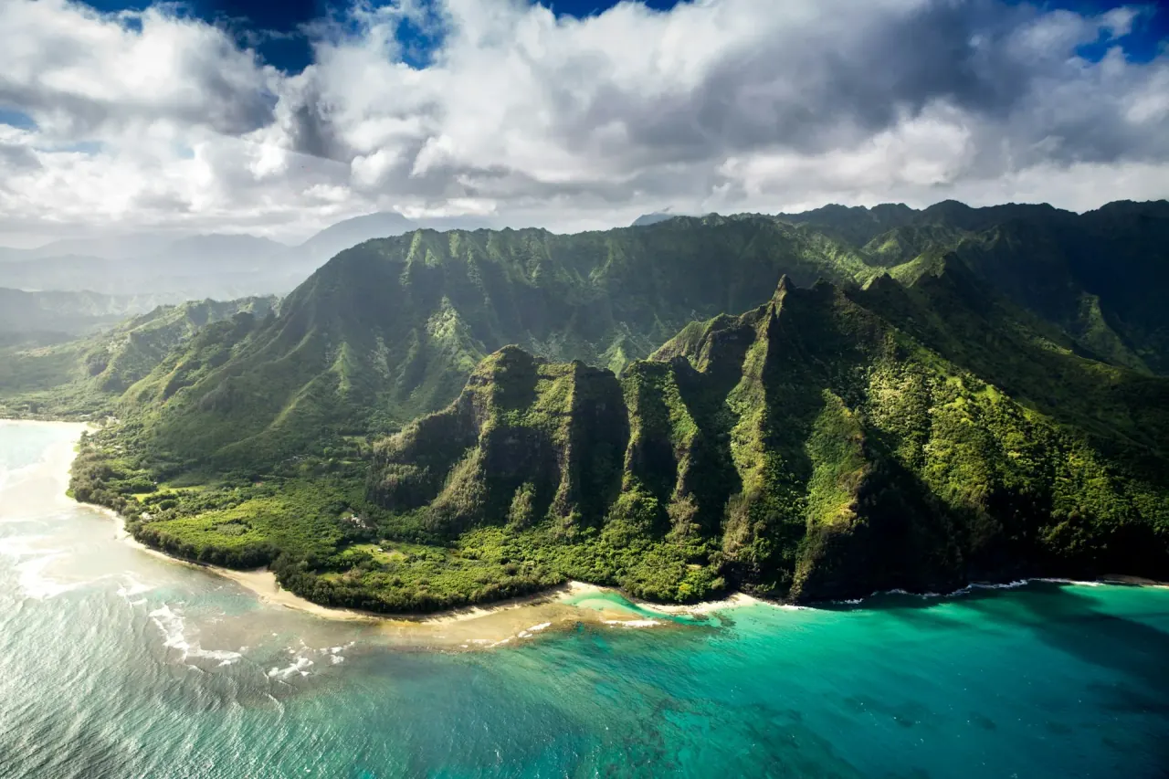
Hawaii Big Island Loop (300 miles, 5–7 days)
The Big Island of Hawaii is the only place in the United States where you can drive from a tropical beach through a rainforest, across a volcanic desert, past active lava flows, and up to a snow-capped summit — all in a single day. The loop around the island is roughly 300 miles, and the diversity of landscapes per mile driven is unmatched anywhere in the country. Budget: $2,800–4,800 for two people over 5–7 days. Car rental in Kona runs $55–80/day (book early — Big Island rental cars are limited and prices surge in peak season). Gas is $5.20–5.80/gallon on the island. Lodging ranges from $30–45/night at county beach park campgrounds (permit required, available online) to $150–250/night at hotels in Kona or Hilo. Food is expensive across the board — budget $60–100/day for two. Best month: May or September. The Big Island has microclimates — Hilo side gets 130+ inches of rain per year while Kona side gets 15 inches — so the west coast is reliably sunny year-round. But the shoulder months avoid peak-season pricing and make park reservations easier. Top 3 stops: Hawaii Volcanoes National Park ($30/vehicle — walk the Kilauea Iki trail across a solidified lava lake, 4 miles roundtrip, and check with rangers about current lava flow viewing), Waipio Valley Lookout on the Hamakua Coast (a stunning amphitheater valley accessible only by 4WD or on foot — the lookout view is free and spectacular), and Hapuna Beach State Park on the Kohala Coast ($5 parking — consistently rated the best beach in the state for swimming and body surfing). Honest downside: The Big Island is expensive. Everything — food, gas, lodging, activities — costs 20–40% more than the mainland. The Saddle Road crossing between Kona and Hilo is long and monotonous through lava fields. The Hilo side rains almost every day, often heavily. And the drive to Mauna Kea summit (13,796 feet) requires a 4WD rental upgrade ($100–140/day) and acclimatization time — altitude sickness is real and the road is unpaved for the last 8 miles.
Rental Car Strategy: How to Save $200–500 on Any Road Trip
The rental car is the second-biggest expense on any road trip after lodging, and the price swings are enormous. The same car, same dates, same company can vary by $30–50/day depending on where and how you book. Here is what I have learned across dozens of rentals in 2024–2026. Book from non-airport locations. Airport rental counters charge concession fees, facility charges, and tourism taxes that add $10–20/day to the advertised rate. Picking up from a downtown or suburban location — even if it means a $15 Uber from the airport — typically saves $15–30/day. Over a 7-day trip, that is $100–200. Use Autoslash and Costco Travel. Autoslash monitors rental car prices and rebooks automatically when rates drop. Costco Travel members get exclusive rates that are consistently $5–15/day cheaper than the same cars on the rental company's own website. Both are free to use. Book the smallest car and hope for an upgrade. Compact and economy cars are cheaper to reserve, and rental lots frequently run out of small cars — resulting in a free upgrade to a mid-size or full-size. This works roughly 40% of the time in my experience, especially at off-airport locations. Skip the rental company's insurance. Most US credit cards (Chase Sapphire, Amex Platinum, Capital One Venture) include primary or secondary rental car collision coverage. Check your card's benefits before paying $15–30/day for the rental company's CDW/LDW. International visitors should check their home auto insurance policy or travel insurance — many cover US rentals. Gas budget rule of thumb: Calculate your total route miles, divide by your car's MPG (assume 28 MPG for a mid-size sedan), and multiply by the local gas price. A 1,000-mile trip in a 28 MPG car at $3.50/gallon costs roughly $125 in gas. For California and Hawaii, budget $5.00–5.80/gallon. For the Southeast and Midwest, budget $2.80–3.40/gallon.
Editor's tips
- Always photograph the car's existing damage at pickup — email the photos to yourself with a timestamp as insurance against false damage claims
- Returning the car with a full tank is almost always cheaper than paying the rental company's fuel charge ($6–9/gallon at most companies)
- Turo (peer-to-peer car rental) can be 20–30% cheaper than traditional agencies for longer trips, especially for SUVs and trucks needed for mountain roads
Camping vs. Motels: The Budget Decision That Shapes Your Trip
The single biggest cost lever on any US road trip is where you sleep. The gap between camping and motels is wide — $25–45/night versus $90–160/night — and over a 7-day trip, that difference adds up to $400–800. The case for camping: National and state park campgrounds put you inside the landscape. Waking up in Big Sur, or next to a Utah canyon, or on the Oregon coast is an experience that no roadside motel replicates. Most campgrounds have restrooms, fire rings, and picnic tables. If you already own a tent and sleeping bag, the marginal cost is just the site fee. KOA campgrounds ($35–55/site) add showers, laundry, and sometimes a pool — a good middle ground. The case for motels: After 8 hours of driving, setting up a tent in the dark is miserable. Motels offer a shower, a bed, climate control, and — crucially — the ability to charge all your devices and plan the next day using actual Wi-Fi. For road trips through the desert Southwest in summer or New England in late October, climate control is not a luxury. My recommendation: the hybrid approach. Camp at the scenic highlights (Big Sur, Bryce Canyon, Acadia, the Oregon coast) and motel at the transit stops between them. A 7-day trip with 4 nights camping ($35/night = $140) and 3 nights in motels ($120/night = $360) costs $500 total — versus $840 for 7 motel nights or $245 for 7 camping nights. The hybrid approach gives you the best experiences at the scenic stops without the misery of setting up camp when you are exhausted. Essential camping gear for road trips: A 3-person tent ($100–200, REI Co-op Half Dome is the standard), two sleeping bags rated to 30 degrees F ($60–120 each), sleeping pads ($30–60 each), a camp stove ($25–50, the MSR PocketRocket is nearly indestructible), and a cooler for food. Total gear investment: $300–550. If you camp 10+ nights per year, the gear pays for itself in the first season.
Compare Road Trip Flights
Many of these road trips start from cities you will need to fly into. Compare live airfare prices across all major US airports to find the cheapest starting point for your route.
Frequently asked questions
A 7-day US road trip typically costs $1,500–3,500 for two people, depending on route, lodging style, and season. The breakdown: rental car $280–490, gas $100–300, lodging $250–1,120 (camping at $35/night vs motels at $160/night is the biggest variable), food $350–700, and activities/park fees $50–200. The Pacific Coast Highway and Hawaii Big Island loop are the most expensive routes due to high gas prices and lodging costs. The Blue Ridge Parkway and Oregon Coast are the most budget-friendly. Booking rental cars through Autoslash or Costco Travel and mixing camping with motels are the two most effective ways to cut costs.
The best American road trip is the one where you stop checking the odometer and start noticing the landscape. Every route on this list has a moment — the first time the Pacific comes into view south of Half Moon Bay, the instant Bryce Canyon's hoodoos appear around a bend, the stretch of Seven Mile Bridge where the ocean fills every window — when the driving itself becomes the destination. Pick the route that matches your timeline and budget, book your car and your first night, and leave the rest of the itinerary loose enough that you can pull over when something catches your eye. That is the whole secret to road tripping in America: the plan gets you started, but the detours make the trip.
Get there
Flights
One search across 700+ airlines — find the real lowest fare for your dates.
Search flightsWhere to stay
Hotels
Browse verified hotels and stays — instant confirmation, secure booking.
Book on KKdayThings to do
Activities
Tours, attractions, and day trips — free cancellation on most experiences.
Book on KlookAbout the author
Marcus Chen
Hotels & Deals Editor · Based in New York City
Marcus reviews hotels for a living — and has slept in over 400 of them. Before TravelBuzzy, he ran the hotel desk at a major loyalty publication and consulted for two boutique hotel groups. He covers the Americas, Japan, and luxury travel.
Read next — destinations

More from The Edit

Itineraries
Route 66 in 2026: The Definitive Road Trip Before the Centennial Crowds Hit
Route 66 turns 100 on November 11, 2026. The anniversary events are selling out, motel prices are climbing, and the window for driving the Mother Road without a crowd is closing fast.
15 min read

Travel Guides
Best Places to Travel in the US in 2026 — A Region-by-Region Honest Guide
48 states. Six years. One observation: the travellers with the best US trips are the ones who pick a region, not a landmark — and go deep instead of wide.
13 min read